Why all the Angry Holiday Drivers?

angry Holiday driver

Why does driving during the Holidays often seems more stressful than usual?  Are family issues and frustrations spilling out onto the streets?

I am always especially cautious while driving during the Christmas Holiday.  Driving behavior seems to change a lot during the Holiday and people become more aggressive and impatient on the road.  Is it that people like to take their family or shopping pressure frustrations out on the road?

Yes, traffic is probably slightly worse near shopping malls but regular commutes to work are faster due to people working from home or on vacation.  You can see the frustration on drivers' faces during this time of year.  Especially when they have to stop and wait for someone crossing the street or someone makes a slight driving error in-front of them.

Driving near shopping malls can be especially hazardous.  We have found in our dangerous intersections database that more accidents are occurring at intersections near shopping malls.  Search the previous map link in your area for dangerous intersections near shopping malls.   

10 Ways To Get Respect From Drivers While Riding Your Bike

car passing too close to bike

Why has riding a bike in most cities across the World now become hazardous to your health and you could easily be risking your life and injury.   I have been riding my bike for the last 25+ years to commute around the Hermosa Beach & Manhattan Beach area.  I used to ride my bike for exercise on the streets training for triathlons but ever since I had kids I have stopped.  It is just too risky now and over the years I have seen many injuries and accidents because some drivers don't respect bikers.

It concerns me that driving has become even more hazardous with texting and distracted driving.  However, one thing that has progressed is road rage, especially in the morning.  I can't tell you how many times I have seen angry drivers pass bikers too close.  Why don't more drivers respect the space of bikers on the road?  Don't more drivers realize that kids are riding their bikes to school and need to slow down?  Over the years I have found the following things help to move cars and get more respect from cars while riding.  Passing too close is my biggest pet peeve and here are ways to help get more space.

  • Ride with a group of 2 or more people.  Drivers tend to respect riders more in a group. 
  • Have a quick look over your shoulder if you start to hear a car approaching. 
  • Wear bright colors.  
  • Do your best to hug the side of the road or parked cars. 
  • Don't ride in the middle of a lane because you never know if a crazy driver is approaching.
  • Don't run stop signs or lights. 
  • Don't ride too fast down hills or in areas with heavy traffic.  Stopping safely is everything! 
  • Always be on guard and never relax while riding. 
  • Look inside parked vehicles to make sure a car is not about to pull out or open a car door.  
  • NEVER wear headphones!  

I can't tell you how many times I have almost been hit by a car while riding my bike on the side of the road. Why don't more drivers give proper space to bikers on the road?   Most drivers are courteous and pull over a lane on the road or just ride the median to give ample space.   However, on some rides, there is usually that one "knucklehead" driver who does not respect your space and will pass you without pulling out.  These people know what they are doing because they often look in the rearview mirror to see my reaction.  We need to crowdsource a database of these assholes and their license plates!

I am not an overly aggressive rider and tend to hug the side of the road for just these reasons.  What can be done to solve these problems?  Education or steeper fines for not giving bikers ample space?  Here is a good article that talks about the 9 things that drivers need to stop saying in the bikes vs cars debate.

Here is another article that suggests that drivers think that cyclists are annoying.  Why do motorists get so angry at cyclists?    "It's not because cyclists are annoying,” he writes. “It isn't even because we have a selective memory for that one stand-out annoying cyclist over the hundreds of boring, non-annoying ones (although that probably is a factor). No, my theory is that motorists hate cyclists because they think they offend the moral order.”

ridar bike presence radar

I would like to see bike radar companies like Ridar take off in the future.  If every car has a bike presence sensor and cars were informed that a bike was nearby this could help.  It would be awesome to see companies like Waze have a function for bikers to let drivers know they are nearby.  However, it is going to take widespread adoption by the automakers.  Hopefully, companies like Garmin and Ridar can make this happen and bring the technology to the masses.  

City Found Liable for Faded White Lines at Intersection


In a civil trial launched in Hamilton, Canada a court heard that the stop line on Fifth Concession Road West, where the sedan should have stopped, was faded and virtually invisible to drivers. The sedan instead stopped at the stop sign before pulling out into the intersection. According to the court documents, city staff had identified months earlier that the stop line needed repainting and had recommended it, but hadn't gotten around to it. Court heard there were "regular" accidents at that intersection. Years before the crash, a neighbor had petitioned to have reflective "tiger stripes" painted on the roadway there (which have since been added).

The stop line was faded. As a result, Superior Court Justice Toni Skarica ruled last week that the city, as well as the driver of the sedan, was negligent. "The evidence establishes that the city had committed itself to maintain this stop line and had ample notice that this intersection was a dangerous — if not one of the most dangerous — intersections in the City of Hamilton," the judge ruled. "The city was aware it needed repainting as far as six months before the accident, but it had not been done." The cost of a stop line, according to the court documents, was $50 to $100.

In an email statement Friday, lawyer Michael Smitiuch said the decision "serves as a wake-up call for the city to ensure improvements are made to dangerous intersections to protect public safety." He said that although his client will continue to struggle with his injuries, "the decision will allow (Chiocchio) to have the much-needed care and rehabilitation that he requires and allow him to provide for his young son." He declined to say what amount the city was ordered to pay. On his blog, he wrote, "The losses and damage suffered by the plaintiff were considerable." A city spokesperson said Monday it's "reviewing the decision with outside counsel, who acted on behalf of the city's insurer, to consider options."  Read more

How Many Accidents Occur at Stop Sign Intersections?

stop sign and car crash

National statistics reveal that one-third of all intersection crashes in the United States occur at stop sign controlled intersections – approximately 700,000 crashes annually. And more than 40% of fatal crashes that take place each year happen at stop sign intersections.

  • Common reasons why people run stop signs include: 
  • Inattention 
  • Impatience 
  • Failure to come to a complete stop, referred to as a rolling stop
  • Obstructed view
  • Distracted driving
  • Speeding
  • Reckless driving
  • Driving under the influence.


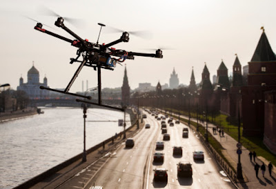
Drones for Traffic Management

NASA & AT&T Developing Drones for Traffic Management

U.S. wireless operator AT&T announced it is teaming up with the National Aeronautics and Space Administration (NASA) to develop a traffic management system for drones. In a press release, AT&T said the goal of the collaboration is the creation of an Unmanned Aircraft System Traffic Management (UTM) solution that will support the safe and secure operation of drones in national airspace. “Working with NASA and others, we are designing the management system for a new frontier in aviation,” AT&T’s Vice President of Global Public Sector Solutions Mike Leff said. “Drones are already used in agriculture, public safety, construction, utilities, real estate, and TV. This research can help support the commercial and private use of drones nationwide.” AT&T said its roll in the project is to bring to the table expertise on networking, the Internet of Things (IoT), the cloud, identity management, and cybersecurity. The carrier said cybersecurity is a particular concern surrounding drones because easy access to the vehicles and their many potential uses could increase the risk of cyberattacks.  Read More

Are these cameras alternatives to the license plate reader cameras currently used on traffic lights?

Most Dangerous Intersections in California

Most dangerous intersections in Southern California

A new study shows the most dangerous intersections in California that have 10 or more accidents, injuries, or fatalities.  based on motor vehicle collision data from 2015. There were 444 total intersections ranked from the 435,000 compiled collision records, according to the data by Statewide Integrated Traffic Records System (SWITRS).

In total, there were 7,294 crashes, 7,478 injuries, and 57 fatalities. The average number of accidents per dangerous intersection was 16.43 and for injuries, it was 16.84. The City of Sacramento had the second-highest total number of dangerous intersections (13) trailing only Los Angeles (221), which is a noticeable difference.  Estey & Bomberger created the map and correlated the data.

We took the intersections and added them to our map of over 9,000 locations Nationwide.  Do a search for "California" and you will find these ranked locations.

Did Edison Workers Cause The Deadly 10 Freeway Bus Accident?

10 freeway bus crash wreckage

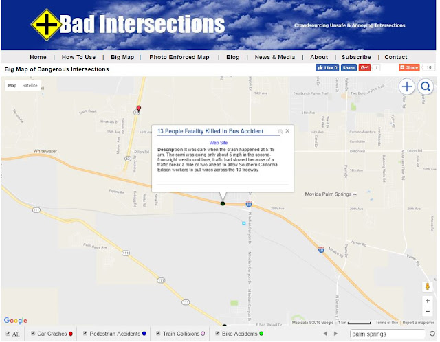
Of course the "Drive By Media" does not report that So Cal Edison & CHP might be partly to blame for the deadly bus accident.  It was dark when the crash happened at 5:15 am. The semi was going only about 5 mph in the second-from-right westbound lane; traffic had slowed because of a traffic break a mile or two ahead to allow Southern California Edison workers to pull wires across the 10 freeway.
"An Edison maintenance crew had slowed down traffic on Interstate 10 before the vehicles crashed just north of the desert resort town of Palm Springs, California Highway Patrol Border Division Chief Jim Abele said. The work had gone on for hours without problems, he said. CHP officers had been slowing traffic to allow Southern California Edison workers to string wires across the freeway, Abele said."
map of 10 freeway bus crash location
10 Freeway Accident Location After Curves
map of 10 freeway bus crash location
10 Freeway Deadly Bus Accident Location
As you can see the accident occurred near a curve on the 10 freeway.  Cars and trucks are often moving at 75-90+ MPH on this section of freeway.

Did the California Highway Patrol give proper warning to drivers westbound?

Did So Cal Edison properly warn drivers that they were stopping traffic miles ahead?

Were there warning signs placed on the freeway miles back to warn of the potential slow down?

I am curious if Waze was warning drivers at the time of the slow down on their app at 5am?

Seems to me that this could have been prevented and not a lot is being reported on the topic.


Dangerous Train Collision with Truck at Intersection

Train smashes into semi-truck stuck on railroad tracks


In Atwater, California a truck driver was nearly hit by the train after truck gets stuck on the tracks. An abc30insider captured the moment a train smashed through a truck in Atwater. The driver had just seconds to escape.

Here are some key points regarding train collisions with trucks at intersections:

Potential Causes: Train collisions with trucks at intersections can occur due to various factors, such as:

Failure to obey traffic signals: Trucks attempting to cross railroad tracks may fail to yield the right of way to an approaching train.

Inadequate warning systems: Insufficient or malfunctioning warning systems, such as malfunctioning gates, lights, or bells, can contribute to accidents.

Driver distraction: Distracted driving, such as using mobile devices or being inattentive, can prevent truck drivers from noticing or responding to train signals.

Mechanical failure: Mechanical issues, such as brake failures or steering problems, can make it difficult for trucks to clear the tracks in time.

Poor visibility: Limited visibility due to weather conditions or obstructed sightlines can make it challenging for truck drivers to see or judge the distance of an approaching train.

Safety Measures: To mitigate the risk of train collisions with trucks at intersections, various safety measures can be implemented:

Improved signage and road markings: Clear signage and visible road markings can help alert truck drivers to the presence of railroad tracks and the need to yield.

Advanced warning systems: Effective warning systems, including active warning lights, gates, and audible signals, can provide advanced notice to truck drivers about approaching trains.

Education and training: Providing training and education to truck drivers on railroad crossing safety and the importance of yielding to trains can help raise awareness and reduce accidents.

Collaboration between transportation authorities: Collaboration between transportation authorities, including road and rail agencies, can help identify high-risk intersections and implement targeted safety measures.

Should The Apple Self Driving Car Tell You Where The Dangerous Intersections Are?

small white 4 passenger electric car prototype
Apple Self Driving Car
Don't you think the Apple self driving car should know where the dangerous intersections are?  Waze already has a dangerous intersections warning on their app.  Google owns Waze and most certainly will integrate their dangerous intersection data into the driving experience of their self driving cars.  

This is Why LAX Traffic is Such a Mess!

satellite image showing Southwest construction wall causing traffic problems
Southwest Terminal 1 Construction & Drop-Off Bottleneck

Look at the satellite image picture above.  When is the last time you saw no traffic during the day when dropping off at LAX?   LAX drop-off traffic is a complete mess and has been ever since Southwest Airlines embarked on their new terminal 1 construction.  It now takes passengers up to 30 minutes just to get into the airport once you are nearby.  On several occasions, it has taken me 20 to 30 minutes just to get from underneath the tunnel to the drop-off gate at terminal one.  It doesn't matter if it's noon in the middle of the workweek or 4:30 am.  The delays of getting into the terminal are ridiculous and caused by a poorly designed construction plan.

The wall you see in red is consolidating traffic from 6 lanes down to 4.  Traffic merging and Southwest drop-off are causing the bottleneck that backs up for almost a mile outside of the airport. I have been flying out of the Southwest terminal for two decades and traffic never used to be this bad even during the busiest rush hour periods.  Cars used to be able to flow in and out of terminal 1 drop-off freely without a bottleneck.

United & Southwest traffic view of red and green at LAX
LAX Southwest Terminal Traffic Congestion

No police officer or traffic manager is capable of managing or correcting the flow after the light.  It doesn't take a genius to see that cars are getting stuck trying to drop off passengers because they now are forced to drive a few hundred yards further.

What is this wall protecting and why does it have to stick out and cut off 2 lanes of drop-off traffic?  The wall looks to be useless has caused hundreds of thousands of passengers to miss their flights who don't arrive 2 before their flight.  Can they simply remove it or push it back until the end of the construction project?

You can thank these companies for the $500M 4 year construction plan & ridiculous mess that looks to be with us until 2018:  AvAirPros, ODEMCO, PGAL and Hensel Phelps Construction Company.

AvAirPros, ODEMCO, PGAL, Hensel Phelps Construction
LAX Terminal One Construction Managers
It is obvious that nobody from any of these companies above did any traffic studies on the impact of cutting off 2 lanes from 6 down to 4 that feed into the terminals.  I am also surprised to see very little news coverage on the topic.  The news seems to attribute the problem to the increased traffic volume of passengers but I know this is a completely false excuse.

Are any executives from LAX doing anything about the problem?

Have any other airlines thought about taking legal action against these companies or LAX for the miss-management?

Flying out of other regional airports is becoming a more viable option these days even though I live 10 minutes from the airport.  It now takes me just as long for me to get to John Wayne Airport (40 miles away) as it does to LAX (5 miles).

I would love to hear your comments below.  Please send this blog post to your friends, politicians, and LAX officials.  Let's get this problem solved quickly.

Listening to the Republican National Convention speech about Donald Trump fixing an ice rink years in a few months and millions of dollars cheaper than the Government inspired me to write this lengthy blog post.  My gut tells me this is just incompetence and not an oversight because nothing is being done to fix the obvious problem.  I think LAX is a prime example of bureaucracy getting into the way of fixing things quickly and efficiently.   Hopefully, this blog post will be read by the people in charge and take action.  

Last Minute Flight Deals!

Bus Stops & Dangerous Pedestrian Intersections

blue and white bus stop sign
Bus Stops & Dangerous Pedestrian Intersections

It is no surprise that bus stops and dangerous pedestrian intersections are highly correlated. Dangerous Intersections have found while we have mapped over 8,000+ dangerous intersections in the last year that pedestrians are very vulnerable at these locations.  Drivers need to be more aware of bus stop locations for pedestrians to cross the street.  We are looking to get these dangerous intersections near bus stops on our map.  

Bus stops located near dangerous pedestrian intersections can pose a safety concern for pedestrians, particularly when crossing busy roads to access or leave the bus stop. Here are some considerations regarding bus stops and dangerous pedestrian intersections:

Visibility: The visibility of pedestrians and drivers at bus stops is crucial for safety. Bus stops should be located in areas with good visibility, allowing drivers to see pedestrians waiting or crossing the road and enabling pedestrians to observe oncoming traffic.

Traffic Calming Measures: Implementing traffic calming measures near bus stops and dangerous pedestrian intersections can help reduce vehicle speeds, improve pedestrian safety, and provide a safer environment for bus users. These measures may include speed humps, raised crosswalks, or traffic islands.

Signalized Crosswalks: Installing signalized crosswalks or pedestrian-activated traffic signals near bus stops can enhance safety by providing dedicated crossing times for pedestrians, allowing them to cross the road safely.

Sidewalks and Pedestrian Infrastructure: The presence of sidewalks, footpaths, and proper pedestrian infrastructure near bus stops is essential. This allows pedestrians to access the bus stop without having to walk on the road or through hazardous areas.

Adequate Lighting: Proper lighting around bus stops and at dangerous pedestrian intersections enhances visibility and improves safety, particularly during low-light conditions or at night.

Clear Signage and Markings: Clearly marked crosswalks, signage indicating the presence of a bus stop, and visible markings can help guide pedestrians and drivers, promoting safer interactions at bus stops and nearby intersections.

Public Awareness and Education: Educating both pedestrians and drivers about bus stop safety and the need to exercise caution at dangerous pedestrian intersections can help raise awareness and reduce the risk of accidents.

Local transportation authorities, municipalities, and transit agencies are responsible for evaluating and addressing safety concerns at bus stops and dangerous pedestrian intersections. They conduct assessments, implement safety measures, and monitor the effectiveness of interventions to ensure pedestrian safety.


Dangerous Railroad Crossing With No Warning or Crossing Arms

Railroad & Road Intersection with no Crossing Arms

A dangerous intersection that has been the scene of several deaths in southwest Arkansas will finally see safety features added.  It only costs $350,000 to add a warning.  Why does it cost so much?  

A railroad crossing without any warning signs or crossing arms can pose a significant safety hazard. It is essential to have proper warning signals in place to alert drivers and pedestrians about the presence of a railroad track to prevent accidents and ensure their safety. If you encounter such a situation, it is important to take extra precautions and follow these guidelines:

Slow down and be prepared to stop: Approach the railroad crossing with caution, reduce your speed, and be ready to stop if you see or hear a train approaching.

Look for other signs: Even if there are no official warning signs or crossing arms, there might be other indicators such as a stop sign, yield sign, or painted markings on the road. Pay attention to any such cues that could warn you about the presence of a railroad track.

Listen for train sounds: Keep your windows down and listen for the sound of an approaching train. Trains make a distinct noise that can be heard from a distance. If you hear a train, exercise extreme caution and wait for it to pass before proceeding.

Look both ways: Before crossing the railroad tracks, look both ways along the track to ensure no trains are coming from either direction. Trains can approach from any direction, so it's crucial to check for any potential danger.

Be aware of train schedules: If you frequently travel across a particular railroad crossing, try to familiarize yourself with the train schedules. Knowing when trains are likely to pass through can help you plan your trips accordingly and avoid potential conflicts.

Report the issue: If you encounter a railroad crossing without proper warning signals or crossing arms, report it to the appropriate authorities. They can take the necessary steps to address the issue and enhance safety measures at that crossing.

Remember, it is crucial to exercise caution and prioritize safety when encountering a railroad crossing without warning signs or crossing arms.

Fatal Car Accidents at Intersections in Florida Heatmap

Heat Map of Fatal Accidents in Florida Reported by FARS
Florida Fatal Car Accidents Heatmap

Every year Florida leads the Nation with the most fatal car accidents at intersections.  Why is this?  Is it because of the older people driving and shouldn't be?  I would be curious if any studies have been done to analyze this fact.  Please post study links in the comments section.  This data was pulled from the FARS (Fatal Accident Reporting System).  

Fatal Car Accidents at Intersections Heatmap Reported to FARS

USA Heat Map of Fatal Car Accidents Reported by the Federal Accidents Reporting System (FARS)
Fatal Car Accidents at Intersections Heatmap Reported to Federal Accidents Reporting System (FARS) from 2010-2015

3D Crosswalk Street Paintings

mother and daughter walking across the street on 3D crosswalk
Do 3D crosswalks slow traffic down?

A mother-daughter artist duo has designed a simple but potentially effective solution to a major road safety problem.

The 2 Largest Revenue Opportunities Of Connected Cars

Safety & Driver Assistance Are the Two Largest Revenue Categories of Connected Cars

Waze warns you about dangerous intersections in 5 big US cities

traffic jam in NYC showing gridlock
Waze Dangerous Intersection
Most navigation apps can get you from A to B while avoiding traffic snarls, but they rarely give you a feel for how risky the drive might be. Is that intersection a cakewalk, or a death trap?

Waze thinks it can help. It's now alerting drivers in five big US cities (Boston, Los Angeles, New York, San Francisco and Washington) when they approach intersections with the historically high crash and injury rates -- get close to one of these danger zones and you'll get a reminder to drive carefully. This won't do anything to stop other drivers from ruining your day, but it should prepare you for the dangers ahead.  Read more

This comment below is particularly interesting to me . . .


Google Maps Show Obvious Dangerous Pedestrian Intersection

dangerous intersection
Wilson & Veitch & Claredon in Arlington, Virginia Dangerous Pedestrian Intersection
The Red Car Pictured Above Is Going The Wrong Direction 

We couldn't find any data to support this claim. However, someone that lives in the area tipped us off about this notoriously dangerous pedestrian intersection in ‪Arlington‬, Virginia‬ shows a red car going the wrong way on ‪Google Maps‬.

Dangerous Train Intersections

Dangerous Train Intersections According to the Federal Railroad Administration
Search the map for #FRA

Train and car accidents can vary widely depending on various factors such as location, traffic conditions, railway infrastructure, and driver behavior. The number of train and car accidents can also vary from year to year.

To obtain the most accurate and up-to-date information on train and car accidents, I recommend referring to reliable sources such as transportation safety agencies, railway authorities, or governmental organizations responsible for collecting and reporting accident data. These organizations often publish annual reports or maintain databases with statistics on train and car accidents.

For train accidents specifically, the Federal Railroad Administration (FRA) in the United States collects and reports data on railroad safety, including train accidents. Their website provides comprehensive information on train accidents and other safety-related data.

For car accidents, the National Highway Traffic Safety Administration (NHTSA) in the United States is a valuable resource. They collect and report data on motor vehicle crashes, including car accidents, providing detailed statistics and analysis on various aspects of road safety.

Polka-Dot Pedestrian Intersections

Austin's Polka-Dot Intersection Experiment

Dangerous Intersections

Map of United States Dangerous Intersections
Heat Map of Dangerous Intersections in the USA