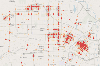
Intersections are where most serious traffic conflicts happen. According to the Federal Highway Administration, over 50% of injury crashes and roughly 25% of all traffic fatalities occur at intersections. While many are routine, others are deceptively dangerous — especially if you're unfamiliar with the area.
Manhattan Beach Pedestrian Deaths and DUI Crashes on PCH / Sepulveda Boulevard
Manhattan Beach, CA – The stretch of Sepulveda Boulevard (Pacific Coast Highway/PCH) between Artesia Boulevard and 9th Street has become one of the most dangerous roadways in the South Bay for pedestrians and drivers. Over the past six months, this corridor has seen multiple fatal crashes, including three pedestrian deaths and a suspected DUI collision, raising urgent concerns among residents and safety advocates.
⚠️ May 3, 2025 – Fatal Suspected DUI Crash on Sepulveda Blvd
At approximately 12:45 a.m. on Sunday, May 3, a pedestrian was fatally struck in the area of Sepulveda Boulevard and Duncan Place. According to the Manhattan Beach Police Department (MBPD):
-
Officers found the victim lying on the roadway next to the suspect’s vehicle.
-
The driver remained on scene and was suspected of being under the influence.
-
The pedestrian was pronounced dead at the scene.
This incident is being investigated as a DUI-related fatality.
🟥 April 19, 2025 – Fatal Hit-and-Run on PCH at Ocean Avenue in Torrance
Just two weeks prior, on April 19, a separate fatal hit-and-run occurred on Pacific Coast Highway at Ocean Avenue in Torrance, resulting in the death of a pedestrian.
According to the Torrance Police Department:
-
Officers responded to reports of a person down in the roadway.
-
The victim was pronounced deceased at the scene.
-
The suspect vehicle fled and has not yet been located.
The incident remains under investigation, and authorities urge any witnesses to come forward.
This highlights a growing regional problem across South Bay cities, with dangerous driving behaviors contributing to pedestrian fatalities on major corridors like PCH.
💥 Other Major Pedestrian Fatalities on Sepulveda Blvd
December 16, 2024 – Pedestrian Killed Near 9th Street
A 72-year-old man, Michael Kawasaki, was struck and killed in the 900 block of Sepulveda Blvd. The driver stayed on scene and cooperated with police.
January 7, 2025 – Fatal Hit-and-Run Near Longfellow Drive
In a hit-and-run crash on the 300 block of Sepulveda Blvd, one person was killed and another critically injured. The suspect was later apprehended.
📉 Why Sepulveda Boulevard Is So Dangerous
1. Hilly Terrain with Limited Visibility
Sepulveda Blvd features steep hills, with intersections like 9th Street and Duncan Place located at hill crests or bases, which significantly limits driver line of sight. Drivers may not see pedestrians or vehicles until it’s too late.
2. Poor Lighting and Infrastructure
Lack of pedestrian lighting, unmarked crosswalks, and minimal safety buffers increases the risk of night-time accidents.
3. High Speeds and Traffic Volume
Though the posted limit is 40–45 mph, many drivers exceed this, especially at night. Coupled with limited visibility, this creates extremely hazardous conditions.
4. Multiple Business Entrances
The corridor is lined with businesses and driveways, causing sudden stops and turns that add to collision risk.
🚔 City Response: Plans to Improve PCH Safety
The City of Manhattan Beach is reviewing multiple safety upgrades, including:
-
Flashing pedestrian crosswalks
-
Improved street lighting
-
Speed feedback signs
-
Raised medians for pedestrian refuge
-
DUI checkpoints and increased patrols
📝 Summary: Recent Fatal Incidents (Nov 2024 – May 2025)
| Date | Location | Type | Outcome |
|---|---|---|---|
| May 3, 2025 | Sepulveda & Duncan Place (MB) | Suspected DUI | 1 pedestrian fatality |
| Apr 19, 2025 | PCH & Ocean Ave (Torrance) | Hit-and-run | 1 pedestrian fatality |
| Jan 7, 2025 | Sepulveda & Longfellow (MB) | Hit-and-run | 1 fatality, 1 critical injury |
| Dec 16, 2024 | Sepulveda & 9th Street (MB) | Pedestrian struck | 1 fatality |
🚶 Safety Tips for South Bay Drivers and Pedestrians
Pedestrians:
-
Cross only at signalized or marked crosswalks
-
Wear reflective gear at night
-
Avoid distractions like smartphones and headphones
Drivers:
-
Obey posted speed limits
-
Be vigilant in low-visibility zones
-
Never drive under the influence
-
Yield to pedestrians at crosswalks and driveways
Don't drive in the far right lane
Don't park on PCH
⚠️ Final Thoughts
With multiple pedestrian deaths across Manhattan Beach and Torrance in just a few months, Sepulveda Boulevard and PCH are proving increasingly deadly. Local governments, police departments, and residents must act now to enhance safety and hold reckless drivers accountable before more lives are lost.
Is A City Liable For An Accident In A Dangerous Intersection?
Traffic accidents at dangerous intersections are unfortunately common, often leading to severe injuries or even fatalities. But when an accident occurs, an important question arises: can the city be held liable for negligence in maintaining a safe roadway?
In this article, we’ll explore the legal factors determining a city's liability for accidents at hazardous intersections and what steps you can take if you’ve been involved in such an incident.
When Can a City Be Held Liable?
Cities are responsible for maintaining roads, traffic signals, signage, and overall infrastructure to ensure public safety. However, proving a city's liability for an accident at a dangerous intersection is often complex and depends on the following factors:
1. Negligent Design or Maintenance
- Faulty Road Design: If the intersection’s design inherently increases the risk of accidents, the city could be held accountable.
- Poor Maintenance: Malfunctioning traffic lights, faded road markings, or obstructed signs can lead to accidents and liability claims.
2. Failure to Address Known Hazards
- Prior Complaints: If residents or drivers have reported issues, but the city failed to act, it may strengthen the case for liability.
- Accident History: A high frequency of accidents at the same location can indicate a known problem that the city neglected to fix.
3. Violation of Traffic Safety Standards
- Non-Compliance: Intersections that fail to meet federal or state traffic safety guidelines could implicate the city in negligence.
- Temporary Hazards: Construction zones without adequate signage or barriers can also lead to municipal liability.
Challenges in Proving a City’s Liability
Filing a claim against a city for an intersection-related accident involves several hurdles:
1. Government Immunity
Cities often have legal protections under “sovereign immunity,” which limits their liability in certain cases. Exceptions exist, but these vary by state and municipality.
2. Statute of Limitations
The timeframe for filing a claim against a government entity is typically shorter than for standard personal injury lawsuits. Failing to act promptly can result in losing your right to compensation.
3. Burden of Proof
You must prove the city's negligence directly contributed to the accident. This often requires evidence such as:
- Accident reports
- Photographs of the intersection
- Witness testimony
- Expert opinions on road design or traffic engineering
Steps to Take After an Accident at a Dangerous Intersection
If you suspect a city’s negligence played a role in your accident, follow these steps:
- Document the Scene: Take photos of the intersection, road conditions, and any contributing factors like missing signage.
- File a Police Report: Ensure the incident is officially documented.
- Consult an Attorney: Legal experts can assess the viability of your claim and guide you through filing against a municipality.
- Submit a Government Claim: In many cases, you must file a formal notice with the city or county before pursuing a lawsuit.
What cities have been sued for dangerous intersections?
Conclusion
Cities have a duty to maintain safe intersections, but proving their liability for an accident can be legally intricate. If you’ve been involved in an accident at a dangerous intersection, understanding your rights and acting swiftly can make all the difference.
For personalized guidance, consult with an experienced traffic accident attorney to evaluate your case and explore your options.
How to Disable a Self-Driving Cars with Traffic Cones
Innovative or Malicious? SF Group Targets Self-Driving Cars with Traffic Cones
Enhancing Intersection Visibility Safety: Blind Spots & Pedestrian Participation
Intersection visibility safety is paramount in traffic management, ensuring the safety of drivers, pedestrians, and cyclists alike. However, the presence of buildings, bushes, and other obstructive elements can pose significant challenges to visibility, increasing the risk of accidents. In this article, we delve into the importance of intersection visibility, the obstacles presented by obstructive elements, and strategies to mitigate risks effectively. Additionally, we explore how pedestrian participation, particularly through the use of reflective clothing at night and avoiding headphone use, can contribute to enhanced safety.
Why Manual Bikes Are Safer Than Electric Bikes on the Road
In recent years, electric bikes (e-bikes) have surged in popularity due to their convenience and ease of use, particularly for commuting and long-distance travel. However, when it comes to safety on the road, manual bikes still hold a significant edge over their electric counterparts. This article explores the various reasons why manual bikes are considered safer than electric bikes for road travel.
Why Are Intersections Dangerous?
According to studies, an intersection where at least three fatal crashes have occurred should be considered deadly. Intersections can be dangerous for several reasons:
Most Dangerous Intersections in America
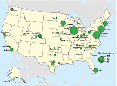
Map & List of U.S. Cities With Bike Sharing Programs
Blind Intersection Drivers Test
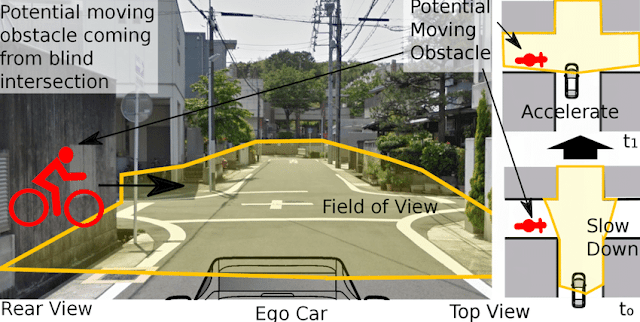
When you approach a blind intersection, it means you can't see any traffic.
A blind intersection is where you approach a corner and cannot see if there is any traffic coming from the left or right.
When driving at night, approaching a blind intersection can be more difficult, as headlights from other vehicles may be shining directly in your eyes. But you still must follow the same rules as you would during the day.
As you begin to slow down before reaching a blind intersection, make sure that no one else is trying to enter it from either side. If it is safe for you to turn right or go straight ahead, do so carefully and watch out for any pedestrians that might be crossing the road.
Make sure there is no traffic.
Check for oncoming traffic and make sure there is no one coming through the intersection from the left. The last thing you want is to have a vehicle come zooming past you in the middle of your turn.
Check for pedestrians. This includes people walking, running, or skating across the street to your right or left. They might not stop if they see you perform a U-turn and could potentially get hit by your car.
Check for bicycles. Bicycles are another difficult-to-spot threat at intersections, especially if they are riding fast and/or weaving in between cars on the road. Make sure that you look out for anyone biking either across or down the street as well before making your turn.
Check for vehicles turning into the intersection from any direction (including behind you). You don't want these cars to end up blocking your path during their turns when you're trying to drive off after completing yours; it's never fun when two cars collide while trying to perform turns at an intersection!
Always slow down and be prepared to stop
If you’re driving in a state or province with a blind intersection, you should always be prepared to stop. If you do not have to stop at a blind intersection, it is recommended that you still slow down significantly, as the most common reason for failure at a blind intersection is not stopping when necessary.
Stop completely at the stop sign.
When you see a stop sign, make sure you come to a complete stop before the stop line. If there is no stop line, stop before the crosswalk or intersection.
While stopped, you must yield the right of way to anyone else in the intersection or who is within 30 meters (100 feet) of the intersection and is approaching it. Make sure you can clearly see in both directions before proceeding through the intersection.
If there is no traffic, proceed through the intersection.
If you are sure there is no traffic coming, you can proceed through the intersection. If you are not sure, do not proceed until it is clear. If there is traffic coming, you must wait. If there is a stop sign or stop line at your intersection and you have to wait for other traffic to clear before proceeding, come to a complete stop.
Do not attempt to turn into a blind intersection if there is any chance of other vehicles being present.
Before you enter the intersection, stop at the stop sign. Be sure that you cannot see any approaching traffic from either direction. In this situation, you should wait for all oncoming traffic to clear. Do not proceed until there is no more traffic coming from the right or left. Remember: a blind intersection is one where oncoming vehicles are not visible to each other until they enter the intersection.
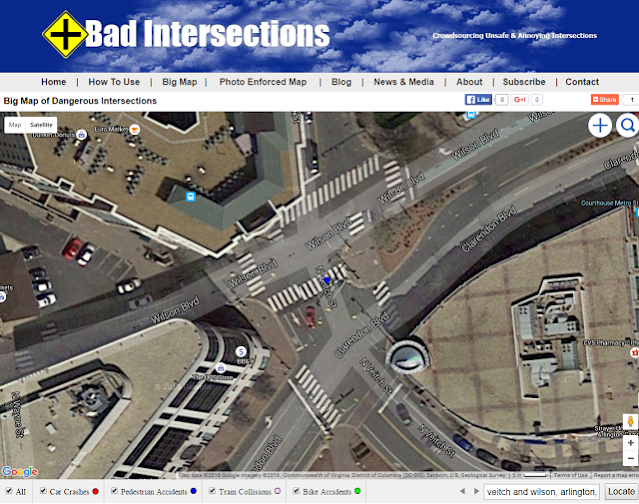
Badintersections.com has a database of dangerous blind intersections. Please add new blind intersections to our map.
Pedestrian Fatalities National Map
Waze Dangerous Intersection Warning
What Is A Blind Intersection?
According to the DMV’s Driver Handbook, “an intersection is considered “blind” if there are no stop signs at any corner and you cannot see for 100 feet in either direction during the last 100 feet before crossing. If your view is blocked, move slowly forward until you can see.”It also applies to where you can't see where traffic is coming from because obstacles like trees, buildings, cars could be blocking your view. Stop signs or other traffic signals are usually absent in such scenarios.
Traffic accidents are a serious public safety problem everywhere, but statistics show that more accidents occur on certain roads and at certain intersections. A frequently cited statistic is that 80% of all collisions involving injured or dead people in cities occur at signal-controlled, light-controlled intersections, according to the US Department of Transportation. The average speed at intersections in the city is often over 35 mph.
In most cities, there are many dangerous intersections with dangerous blind intersections. Poorly designed intersections can have blind spots that block the driver's field of vision and make it difficult to see oncoming cars. In some cases, motorists do not comply with the applicable laws and regulations on stopping at stop signs, even if they have stopped at a stop sign. A poorly designed intersection could have a blind spot that impedes a driver's field of vision and makes it harder for him to see oncoming vehicles, cyclists, and pedestrians.
The majority of collisions at stop-light controlled intersections happen within 4 seconds of a light change. You don't want to be in the intersection during that 4 seconds. However, if you don't immediately go when the light turns green, people behind you get irritable, yes? Try this defensive driving tip.
The first thing is to make sure you stopped in the right spot. Stop far enough behind the stop line that you can see it on the pavement in front of your car - this normally gives you 10-15 feet of space. When the light turns green, take your foot off the brake and let your vehicle start to creep toward the crosswalk.
Common sense tells you that crossing a controlled intersection with a traffic light is much safer,. However, be careful turning right on red-light and give pedestrians sufficient time to make calculated decisions about the safety of turning right and to ensure that pedestrians do not cross the road and oncoming traffic does not enter the dangerous junction. Look out for cyclists and pedestrians crossing the intersection in both directions while driving. They are legally allowed to enter the middle of the intersections and wait for cars to pass before passing them.
Note that some states, such as Arizona, require that unregulated intersections be treated as four-way stops and that you come to a complete halt before driving through. When you arrive at a junction where you want to turn right - to the left - and there is no other traffic in sight, do not follow the correct lane as you approach the junction.
LA Times Most Dangerous Intersections
5G Technology to Help Monitor Dangerous Intersections
What is a smart intersection and how does 5G help?
The system of sensors, video-based detection, connected traffic signals, and remote monitoring capabilities, provided by traffic systems technology company Miovision, has been deployed across five intersections along a busy corridor in the heart of Detroit. Smart traffic technology from Miovision has already been deployed in over 40 percent of the intersections in Detroit and now San Diego is looking to do the same.
Continental and Panasonic are a few other companies in the smart intersections game.
Using the new AI technology, the intersections are able to sense and understand what’s happening on the roadways in real-time and trigger responses, such as:
- Traffic lights that can lengthen green lights to accommodate cyclists who wouldn’t otherwise be able to make it through the intersection
- Alerts that warn drivers of connected cars or Waze (connected app) users that jaywalkers are ahead
- Traffic lights that provide priority access to emergency and police vehicles
- Intersections that understand and analyze the near misses between users such as pedestrians in the crosswalk, cyclists, and drivers
- Traffic lights allow for freight vehicles to have green light priority, encouraging freight use on certain intersections away from pedestrian-heavy corridors.
- A faster network will also allow for autonomous driving in San Diego. Smart cars will rely on sensors around the city to pick up on someone running across the street or another car turning the corner.
Buying a Home In A Safe Neighborhood
If you are buying a home these days you should probably do your due diligence on dangerous intersections that are within a few blocks of your home. Especially if you have kids and these kids like to play outside and walk to school or around the neighborhood. Common sense would tell you that your local government should provide a map of these hazardous intersections and provide this data to Google Maps and other navigation sources. Does this happen? Off course it doesn't!!!


